


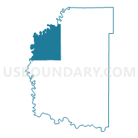
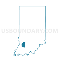
STEELE 1, Daviess County, Indiana
About
Outline

Summary
| Unique Area Identifier | 576731 |
| Name | STEELE 1 |
| County | Daviess County |
| State | Indiana |
| Area (square miles) | 43.39 |
| Land Area (square miles) | 42.76 |
| Water Area (square miles) | 0.63 |
| % of Land Area | 98.54 |
| % of Water Area | 1.46 |
| Latitude of the Internal Point | 38.78284780 |
| Longtitude of the Internal Point | -87.18054230 |
Maps

Graphs
Select a template below for downloading or customizing gragh for STEELE 1, Daviess County, Indiana


Neighbors
Neighoring Voting District (by Name) Neighboring Voting District on the Map
- BOGARD 1, Daviess County, IN
- ELMORE 1, Daviess County, IN
- ELMORE 2, Daviess County, IN
- VIGO 01, Knox County, IN
- VIGO 02, Knox County, IN
- VIGO 3, Knox County, IN
- WASHINGTON 1, Daviess County, IN
- WASHINGTON 2, Daviess County, IN
Top 10 Neighboring County Subdivision (by Population) Neighboring County Subdivision on the Map
- Washington township, Daviess County, IN (15,534)
- Vigo township, Knox County, IN (4,031)
- Bogard township, Daviess County, IN (1,473)
- Elmore township, Daviess County, IN (1,113)
- Steele township, Daviess County, IN (903)
Top 10 Neighboring Place (by Population) Neighboring Place on the Map
Top 10 Neighboring Unified School District (by Population) Neighboring Unified School District on the Map
- Washington Community School Corporation, IN (17,325)
- North Daviess Community Schools, IN (8,881)
- North Knox School Corporation, IN (8,842)
Top 10 Neighboring State Legislative District Lower Chamber (by Population) Neighboring State Legislative District Lower Chamber on the Map
Top 10 Neighboring State Legislative District Upper Chamber (by Population) Neighboring State Legislative District Upper Chamber on the Map
Top 10 Neighboring 111th Congressional District (by Population) Neighboring 111th Congressional District on the Map
Top 10 Neighboring Census Tract (by Population) Neighboring Census Tract on the Map
- Census Tract 9543, Daviess County, IN (3,758)
- Census Tract 9551, Knox County, IN (2,926)
- Census Tract 9544, Daviess County, IN (2,731)
Top 10 Neighboring 5-Digit ZIP Code Tabulation Area (by Population) Neighboring 5-Digit ZIP Code Tabulation Area on the Map
- 47501, IN (17,535)
- 47512, IN (3,981)
- 47529, IN (1,042)
- 47568, IN (834)
- 47578, IN (776)
- 47528, IN (476)